Arab Canada News
News

Published: September 1, 2022
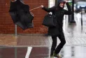
A tornado warning has been issued for parts of eastern Ontario including south Ottawa, Richmond, and Metcalfe.
This warning also applies to Winchester, Newington, Merrickville, Wilford, and Kemptville.
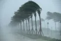
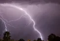
The Canadian Ministry of Environment said that its meteorologists are tracking a severe thunderstorm likely to produce a tornado.
They explained that it could also cause destructive winds, heavy hail, and locally heavy rainfall.
The Ministry of Environment said this is a dangerous and life-threatening situation and urged the public to take shelter immediately if this threatening weather approaches.
The Ministry of Environment warned citizens in a message on various communication platforms, saying if you hear a roaring sound or see clouds, or debris swirling near the ground, or flying debris, or any threatening weather approaching, take shelter immediately.
Meanwhile, the electricity company Hydro Ottawa reported a power outage affecting 3,500 customers, mostly in the Bells Corners and Riverside South areas.
Ottawa’s electricity company said the estimated power restoration time in these areas is midnight.
The rain comes at the end of August where Ottawa has recorded 183.4 mm of rain so far this month.
According to the Twitter account YOW_Weather, this is the third rainiest August in Ottawa since records began.
The record is 204.2 mm, which was in August 1893. Forecasts indicate rainfall of 10 to 15 mm.
The weather tonight is mainly cloudy with a chance of showers.
Temperatures will drop to 10 degrees Celsius.
Tomorrow, Thursday, will be mainly cloudy at the start of the day, with clear skies in the afternoon, and a high of 20 degrees Celsius.
The forecast for Friday is sunny with a high temperature of 27 degrees Celsius, while Saturday will be sunny with a high temperature of 29 degrees Celsius.
Normal temperatures for this time of year are 22 degrees Celsius and a low of 12 degrees Celsius.
Tuesday, 01 July 2025
--°C
--°C


Comments