Arab Canada News
News
Published: August 5, 2024
The authorities in British Columbia have issued an evacuation order for an area located north of the site where the Chilcotin River meets the Fraser River due to the flood risk posed by a landslide.
In a press release issued on Sunday evening, officials in the Cariboo Regional District informed residents to leave "immediately," and that those who choose to stay do so at their own risk. The evacuation order covers 3.5 square kilometers.
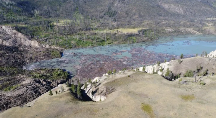
A massive landslide last week in Farewell Canyon, located about 22 kilometers south of Williams Lake, blocked the Chilcotin River and created a lake approximately 11 kilometers long behind the slide.
Sean Leslie, a spokesperson for the Ministry of Water, Lands and Resource Management, said in a statement on Monday that the water trapped behind the natural dam has not yet peaked, despite rising levels overnight. Leslie noted that the rising water levels are similar to what was observed during spring thaw but are expected to move faster and with more force.
He added that experts expect the water to reach the top of the natural dam and begin flowing into the river channel in the coming hours.
The Tsilqot'in Nation stated in a social media post that as of Sunday morning, the slide was holding 61 million cubic meters of water, equivalent to "24,400 Olympic-sized swimming pools."
British Columbia's emergency management agency stated on Sunday that water is expected to begin moving over the top of the massive landslide site within hours.
The agency urged people to stay away from the Chilcotin and Fraser Rivers due to the threat posed by the landslide.
The River Forecast Centre issued flood warnings for the Chilcotin River upstream and downstream after the landslide near Farewell Valley.
A flood warning has been activated for the Fraser River from the confluence of the Chilcotin River downstream to Hope, British Columbia.
The department is scheduled to provide an update on the landslide later on Monday.

Wednesday, 16 July 2025
--°C
--°C


Comments