Arab Canada News
News
Published: August 12, 2024
Some Canadian provinces are expected to experience a wave of thunderstorms, heat advisories, and air quality alerts as summer weather and wildfires continue this week.
Here's a look at the weather forecasts for this week.
Extreme Heat
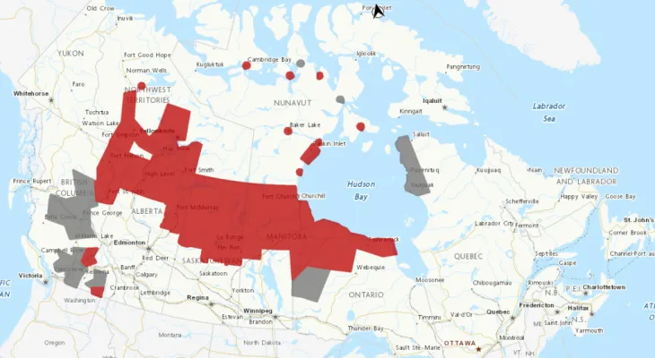
Five provinces and two territories are under heat advisories this week.
In northern Alberta, including Mackenzie County and Wood Buffalo, heat advisories state that warm daytime temperatures nearing 30 degrees Celsius will persist until early next week, according to CTV Your Morning meteorologist Kelsey McEwen.
Environment Canada says temperatures will moderate on Wednesday.
Some areas in British Columbia, Manitoba, and Saskatchewan can expect similar temperatures.
Heat advisories are also being issued across the territories, including Fort Simpson and High River in the Northwest Territories. Forecasts indicate warm temperatures will range from 29 to 35 degrees Celsius during the day. The meteorological agency noted that temperatures will moderate on Tuesday.
In places like Arviat and Baker Lake, in Nunavut, daytime maximum temperatures will reach the mid-20s to low 30s from Monday to Tuesday.
For areas under heat advisories in Nunavut, Environment Canada said the passage of a cold front from Tuesday night to Wednesday will bring the seasonal high daytime temperatures back by Wednesday afternoon.
Poor Air Quality
McEwen noted that air quality advisories are in effect in areas also under heat advisories.
Advisories for regions in northern Alberta, Saskatchewan, and Manitoba indicate that smoke from wildfires is causing, or is expected to cause, very poor air quality and reduced visibility.
The advisories also indicate that air quality can vary over short distances and from hour to hour.
McEwen stated that multiple areas across British Columbia - including Fort Nelson, Whistler, and Fraser Canyon - are under a special air quality statement.
In the statement, Environment Canada states that the fires in the Northwest Territories will have a "more pronounced" effect in southern, central, and northeastern British Columbia over the next 24 to 48 hours.
Regions in the Northwest Territories and Nunavut that are under heat advisories are also subject to air quality advisories.
In northern Ontario and Quebec, smoke is contributing to poor air quality over the next few days.
A statement from Environment Canada warned that "smoke plumes moving over northwestern Ontario due to a series of wildfires in the northern prairies and northern Ontario have degraded air quality."
Thunderstorms
McEwen indicated that there is a moderate risk of thunderstorms expected in southern Alberta on Monday afternoon, with hail and gusty winds.
McEwen added that a slight risk of thunderstorms is expected over most of Alberta and parts of Saskatchewan.
According to McEwen, there is a significant risk that severe thunderstorms may hit Okanagan, British Columbia, with strong winds and heavy rain.
McEwen also noted in Monday's forecast, "We are monitoring potential tropical storm number 5 located near the Leeward Islands in the Caribbean."
The islands include Antigua, Barbuda, Saint Kitts and Nevis, and Saint Martin.
McEwen stated that Ernesto would be the third storm of the year and would move westward across the region.
Friday, 04 July 2025
--°C
--°C


Comments