Arab Canada News
News

Published: June 15, 2024
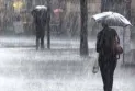
The federal meteorological experts issued weather warnings on Friday in western and northern Canada as well as the Atlantic region. Alerts for severe thunderstorms were sent across the country to warn of heavy hail and wind gusts reaching speeds of up to 90 km/h.
CTVNews.ca followed many weather warnings throughout Canada. These were the latest updates.
Winds 90 km/h, severe thunderstorms in the east
Meteorologists stated that severe thunderstorms brought strong winds, heavy rain, and lightning on Friday afternoon and evening.
A cluster of severe thunderstorms moved quickly eastward. Gusty winds reached up to 90 km/h, which could lead to tree branches being snapped and causing damage to weak buildings.
Severe thunderstorms were observed in these areas:
Acadia Peninsula
Bathurst and Shippagan area
(Campbellton and Restigouche County).
Miramichi
Mount Carlton - Reinus Highway
The weather statement said, "The main threats from these storms will be locally heavy rainfall, very strong wind gusts, and hail the size of peas."
Heavy rains and hail in the west
The Canadian Environmental and Climate Change Agency (ECCC) warned of heavy rains leading to flash flooding in northern British Columbia. In Alberta, severe thunderstorms were recorded in the following areas:
Alberta
A severe thunderstorm warning was issued for these areas:
Elk Island.
Fort Saskatchewan and Strathcona County.
Lamont near Bruderheim, Lamont, and Pino Creek
A general thunderstorm alert was issued for these areas:
City of Edmonton - St. Albert - Sherwood Park
Drayton Valley - Devon - Rimby - Pigeon Lake
Leduc - Camrose - Wetaskiwin - Tofield
Red Deer - Bonnyville - Innisfail - Stettler
Rocky Mountain House - Caroline
Slave Lake
Spruce Grove - Morinville - Mayerthorpe - Evansburg
Wabasca - Pearle Lake - Gift Lake - Cadot Lake
Westlock - Barrhead - Athabasca
Whitecourt - Edson - Fox Creek - Swan Hills
British Columbia
Severe thunderstorms were observed in these areas:
100 Mile
North Thompson
Moose
A rainfall warning was issued for these areas:
British Columbia Northern Peace River
Fort Nelson
Up to 50 cm of rain could fall in the Peace River region in Alberta - Fairview - High Prairie - Manning area - a rural area in the northwest of the province from Friday night to Saturday, according to a rainfall warning.
"Heavy rains can cause flash flooding and water pooling on roads. The warning noted that local flooding in low-lying areas is likely."
Crews rushed to restore power outages
Dozens of thousands of people were left in the dark in Quebec and Ontario as severe thunderstorms struck the area on Thursday and overnight. Some areas were at times under tornado warnings.
An announcement from Hydro One's website stated: "Our crews are out in full force today working as quickly and as safely as possible to restore power after the severe storms that affected parts of the province yesterday." "Stay away from any fallen power lines. If you see a downed line, stay at least 10 meters away, even if it doesn't look live."
Hydro One expected to restore power by 11:30 p.m. at the latest for affected areas, except for Bolton, Simcoe, and Vanleek Hill, where damage assessment is still underway.
Quebec crews worked rapidly to cut remaining power outages throughout the morning and afternoon on Friday.
Snow on the roads
Drivers should be wary of the possibility of snowfall on mountain highways in British Columbia.
Cold air sweeping over the interior is expected to bring heavy rainfall throughout the weekend. Accumulations of up to five centimeters of snow could occur on the following highways:
Coquihalla Highway
Okanagan Connector
Allison Pass
Kootenay Pass
Rogers Pass
The ECCC warning stated, "Weather in the mountains can change suddenly, leading to dangerous driving conditions."
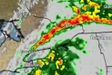
At least one tornado watch was detected by Doppler radar in Quebec about 12 kilometers north of Oskilanyou.
All warnings and watches related to severe weather were lifted as of Friday morning, according to the Canadian Environmental and Climate Change Agency; an end to dozens of alerts and watches from early Thursday morning until late at night.
Severe thunderstorm and tornado alerts came quickly and changed throughout the day, reporting risks of wind gusts reaching 100 km/h and hail ranging from the size of toonie coins to ping pong balls.
"This is a dangerous and potentially life-threatening situation," stated a warning from the Canadian Environmental Agency. "If you hear a roaring sound or see a funnel cloud, debris swirling near the ground, or any threatening weather approaching, seek shelter immediately."
Some areas transitioned from storm watches and warnings to tornado alerts and back throughout the day, extending warnings from northern Lake Superior down to the Greater Toronto Area and eastward to central Quebec.
Some affected residents received emergency alerts on their mobile devices.


Friday, 04 July 2025
--°C
--°C


Comments