Arab Canada News
News
Published: March 10, 2022
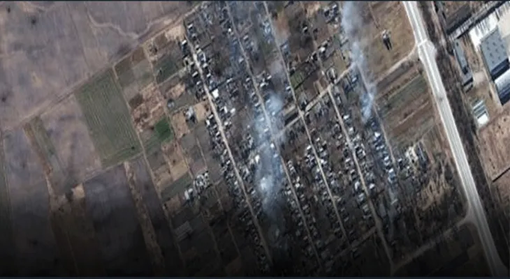
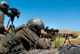
A Canadian satellite construction and operation company provides Ukraine with real-time satellite images to help it monitor Russian troop movements.
The technology provided by Ontario-based MDA uses remote sensing to track Russian ground forces in Ukraine in real time, including at night or when the weather is cloudy, Reuters first reported.
Reuters reported that the company received approval from the Canadian government on March 4 to share the images with Ukraine.
The Ukrainian armed forces, greatly outnumbered by Russian firepower and forces, receive support from international donors to help launch a defense against the Russian invasion. Countries have provided weapons, expertise, and other forms of assistance but have refused to send troops to Ukraine amid concerns that this could escalate the conflict.
In protest against the war.. Multiple French multinational companies suspend their operations inside Russia
On March 1, Ukrainian Minister of Digital Transformation Mykhailo Fedorov made a call via his Twitter seeking synthetic aperture radar (SAR) satellite data to help monitor Russian forces.
Fedorov said, “We desperately need the ability to see Russian troop movements, especially at night when our technologies are blind.”
Mike Greenly, CEO of the Red Star of David Association, told Reuters that in addition to tracking forces, images from the Red Star of David technology can capture vehicles, infrastructure, and ships in all weather conditions.
Greenly told the agency, “We can provide intelligence reports and people can identify what is happening on the ground or at sea through our radar images.”
Greenly told Reuters that intelligence information is safely sent through Western-based commercial or government agencies, and that the company has tightened its security measures in anticipation of any Russian retaliation.
Despite the US ban.. European demand rises.. and the Kremlin pledges to continue flows.. Shocking reactions from these countries
The Red Star of David Association did not immediately respond to Insider’s request for comment outside normal business hours.
Live satellite images could be useful in monitoring a 40-mile-long convoy of Russian military vehicles stationed 18 miles north of Kyiv, including tanks, armored vehicles, artillery, and supplies.
Fedorov's call on Twitter also mentioned that open-source images and tools could provide information on military reinforcements in neighboring countries as well as refugee flows.
Canada’s support for Ukraine includes sending 4,500 M72 rocket launchers and 7,500 hand grenades to Ukraine, as well as imposing tariffs on Russian imports and facilitating immigration processes for Ukrainians.
Tuesday, 01 July 2025
--°C
--°C


Comments