Arab Canada News
News
Published: August 19, 2024
On August 9, as the rain poured relentlessly on southern Quebec, James Murchison and his wife made their way to Montreal from Ottawa on Highway 40.
They had given themselves four hours to do so, although the trip usually took two hours. Murchison had planned to have drinks with friends in the city around 8:30 PM, and the couple was staying at his relatives' home to attend a wedding that weekend.
When they arrived in Kirkland on the western edge of Montreal Island, traffic suddenly slowed down. Water began to rise around them until the road was blocked in front of them and behind them. The water submerged some cars, and before they realized it, Murchison and his wife, along with about 150 other vehicles, were trapped.
Murchison said, "It happened very quickly." The minutes turned into hours. "We were stuck on a little island for six hours."
However, Murchison's ordeal was minor compared to hundreds of Montreal and Quebec residents whose basements were affected – in some cases in the Laurentians and Mauricie regions – due to the heavy rainfall. In Montreal, up to 158 millimeters of rain fell within 24 hours; in other parts of the province, this amount rose to 200 millimeters.
Municipalities across Quebec have faced scrutiny from affected residents, but mayors like Valérie Plante of Montreal defended their work, stating it is impossible to keep up with the growing intensity of heavy rainfall due to climate change.
Plante said in a television interview on Radio-Canada on Tuesday, "In some cities, it's wildfires or hurricanes. For us, it's the water." The mayor mentioned that the city has been replacing underground tunnels – which were neglected for decades – since she took office seven years ago. She cited initiatives to absorb rainwater, including sponge gardens, creating more green spaces, and planting trees. Ultimately, she said, "There will never be zero risk."
But the discovery Murchison made while sitting in his car could provide clues about where the water goes in the city, and on the island as a whole, when there is too much of it.
Am I in a river?
On the stretch of the highway, people got out of their cars and started wandering around. A group played a game of pickleball. Some left, wading through the water and returned with pizza. Murchison wondered why the water was pooling there due to the surrounding geography. He looked at Google Maps and saw a thin blue line near his location, indicating some kind of stream.
Murchison, who had heard that cities were built over small rivers and water networks that were confined to underground tunnels and waterways, in some cases buried, said, "I just feel curious to know if I’m in a river."
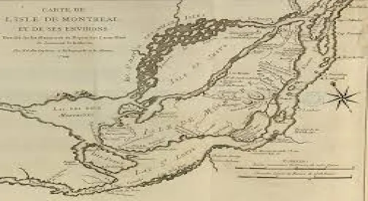
Searching on his phone, he found two maps of Montreal Island dating back to 1744 and 1892, showing an important river where he and all those other cars were sitting.
Old maps reveal all kinds of secrets, and in recent years, with heavy rainfall doubling, scientists and urban planners have turned to centuries-old maps to understand areas that may be prone to flooding.
Because cities are primarily made of concrete, they can't absorb water well, and it ends up traveling until it accumulates in low or flat surfaces. In those places, there may have once been rivers or streams flowing.
Montreal, Toronto, and Vancouver have mostly been built over drainage networks, leading to the diversion and confinement of tributaries into often overloaded sewage systems.
Pascal Rouilly, an urban planner and founder of Les Ateliers Ublo, a company that helps Quebec municipalities with green infrastructure projects, said, "Our terrain reminds us that these waterways exist."
Rouilly added, "In places where waterways were buried, the soil is often already saturated, so it can't absorb more water, and the water cannot find its way into a waterway. This creates a problem."
Continuous flow of water
This has caused problems for Robert de Palligreen and Michael Borstal, who own businesses near one of Montreal's most famous lost rivers at Lachine: the Saint Pierre River.
The water began to fill Borstal’s towing office on Montreal-Toronto Road next to Highway 20 on Friday. By midweek, he was still dealing with the consequences.
Borstal said, "This time was the worst ever. Water flooded our building here by two feet."
While it may have been the worst flooding since Borstal had been in the area for 20 years, it was not the first.
Borstal said, "Every spring when everything starts to melt... it becomes like we’re in a lake."
On the other side of the highway, on a property that Borstal owned, de Palligreen faced similar problems.
De Palligreen said, "There's always a continuous flow of water flowing over our land."
He and his wife, Lucy Doumaise, run the popular Eco Depot thrift store. In 2021, they moved from a rented warehouse down the road to a blue industrial building on Richer Street, down a slope in an area of Montreal known as Ville Saint-Pierre.
That winter, a thick layer of ice covered the property. De Palligreen said Borstal warned him that there would be water come spring. Two months later, a small waterfall appeared on the slope.
De Palligreen said, "I had actually thought about building a small hydropower dam. I dug a hole the size of 10 bathtubs, and it filled up within two or three hours."
After a few floods, de Palligreen installed a French drainage system at a cost of $650,000. He estimates that the company lost another $250,000 due to flood damage and interruption of business.
So, when the rains flooded the streets around the Eco Depot warehouse on Friday, de Palligreen was grateful that the renovations prevented his property from sustaining further damage.
A video shows a sewer grate in the middle of the road covered with water. A Mercedes sedan and a pickup truck struggle to cross.
Earlier this year, CBC News published an interactive report on hidden rivers in Canadian cities. It noted that the last 200 meters of the Saint Pierre River were erased by the City of Montreal in 2022 after a court ordered it to do so in a legal battle with a golf course located above Eco Depot.
Has Montreal crossed the line in managing highways?
On Highway 40, James Murchison said firefighters eventually arrived, checked to make sure everyone was okay, then left. At around 1 AM, the water subsided and was clear enough to move again.
Murchison never went for drinks (his friends even struggled to find a bar with power), but he and his wife managed to attend the wedding.
Jerry Faux, a spokesperson for the City of Kirkland, said in an email, “City teams are still investigating what occurred last Friday on Highway 40, so it would be premature to comment.”
But Murchison still isn't impressed.
He said, "I think you really overbuilt the highway infrastructure in the 1960s."
Rouilly, the urban planner, noted that highways around the world are often at risk of flooding because they lie in low, flat areas where it was easy to build. She and four colleagues from competing firms signed an open letter last week stating that it’s not too late to implement green infrastructure.
The Quebec Ministry of Transportation stated in an email that it is working to update highway infrastructure to make it more resilient to climate change.
Rouilly pointed out that innovations like permeable asphalt could be a future solution, but such materials are often incompatible with heavy machinery like snowplows, as a spokesperson from the Ministry of Transportation noted over the phone.
As for the river that flowed through Highway 40 where Murchison was, it still exists. This happens to be the eight-kilometer tributary called Rivière à l’Orme, which is the last intact river on the island. La Presse published an article on this topic last week.
Saturday, 05 July 2025
--°C
--°C


Comments