Arab Canada News
News
Published: October 2, 2023
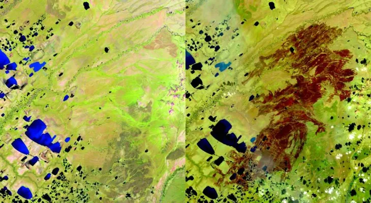
The images captured by satellites show the damage left by some of the worst wildfires in Canada.
Burn scars in red and brown are clearly visible in images provided by the Canadian Space Agency to CTV News in late September.
These "before" and "after" images were taken by the Sentinel-2 satellite, part of the European Union's Copernicus programme, and Landsat 8 operated by the American Geological Survey, as they passed over British Columbia, Yukon, and the Northwest Territories.
The "before" images show the areas as they were observed earlier in the summer: green with trees, grass, and other vegetation. The images taken when the satellite passed later in the season and in the fall reveal burn scars, where the ground was scorched and vegetation burned.
Thousands of people have been evacuated from their homes during one of the worst wildfire seasons in Canada to date. The scale of the fires has made international news as smoke drifted across country borders, reaching Europe in some cases.
Estimates from the Canadian Interagency Forest Fire Centre indicate that 6,474 fires have burned approximately 18.1 million hectares of land this year—181,000 square kilometers, or about 17 million football fields.
The images show some of the largest fires reported in Canada this year.
Yukon
Images of the remote Old Crow area in Yukon were captured on July 10 and September 13. A state of emergency was issued in May for Yukon and the surrounding area, including Old Crow, on August 8, and the images show the natural color as seen from orbit, as well as the same area on July 7 compared to September 1.
Northwest Territories - Yellowknife
These satellite images show the damage from fires in the Yellowknife area. The first image was captured by the Copernicus Sentinel satellite on July 9. The second image shows the area as it appeared when the satellite passed two months later, on September 7.
The images were taken using radar technology and show the same area on July 6 compared to September 16.
Northwest Territories - Hay River and Enterprise
These sensor images taken by Sentinel-2 show the areas of Hay River (first) and Enterprise in the northwest of the country, both of which were evacuation sites earlier this summer due to the fires.
The first image of Hay River was taken on May 2, and it was compared to a shot of the same area four months later.
Images of Enterprise were taken on August 8 and August 23, to show the difference that just two weeks can make.
The Canadian Space Agency also included images captured in natural colors and shortwave infrared of the South Slave Lake area in the territory, and the images on August 28 show that the smoke was significant enough to be visible from space.
Parts of this area have been evacuated since May, with evacuations continuing throughout the summer. Firefighters are still dealing today with hotspots in some parts of the South Slave region, including Enterprise and Fort Smith, where fire risk forecasts have been very high over the weekend.

Thursday, 03 July 2025
--°C
--°C


Comments